Crash Hotspots
Browse the map of 3500+ high incidence crash locations across New Zealand, with custom filters.
Making sense of the mayhem!
NZTA (NZ Transport Agency) collects data on road crash reports provided by the NZ Police. There have been more than 800 thousand crashes recorded since 2000 and more than 8000 fatalities, and NZTA makes this data available. This site represents our example of how this Open Data can be made interactive both for the public and for programmatic use.
Features
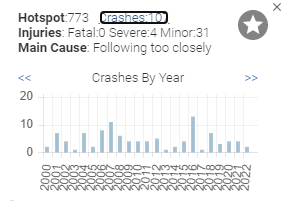
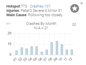
Hotspot analysis allows trends and grouped properties to be used for filtering and to be shown by way of charts and reports for the mobile app and web site. The full view of all crashes is also available on the web site
Charts
Filters
Search
Availabilty
A web site is available for all modern browsers, and a web API is available for programmatic interaction
Web-ready
Web for Phones
Web API